Clarendon County,
SC on the north shore of Lake Marion
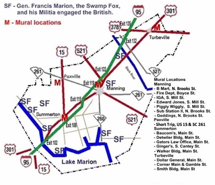
Historic U.S. 301 - “Highway to Southern
Living” Named Swamp Fox Trail in
1925
|
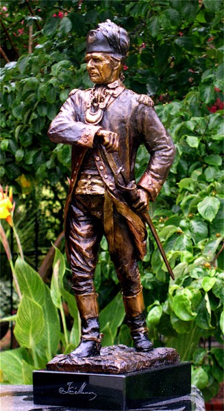
Celebrating General Francis Marion Rev. War Living History Encampment The Best: Feb. 24-25, 2012
Best event ever
-
Francis Marion Symposium Oct 14-15, 2011
Historic Swamp Fox Murals
Trail ©2002 along Historic US 301 in Clarendon
County, SC. |
||

NEW: Artists Welded Sculpture of History: "The Swamp Fox Sets an Ambush" unveiled at FE DuBose Campus/CCTC, I-95, exit 122, April 18, 2012. Thanks to the CCTC & FE DuBose welding student artists, Axel Reis, the Bank of Clarendon and Swamp Fox Murals Trail. |
||
|
New Ox Swamp Marker where Marion got "Swamp Fox" moniker near Pocotaligo Swamp 3-2-2012 Ms Land, Dr. Hardee, Chairman Stewart, Mayor Nelson. Historic Marker: http://www.hmdb.org/marker.asp?marker=51985 Follow Pocotaligo Nature Walk signs. |
||
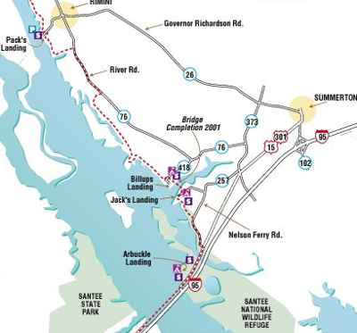
| Santee National Wildlife Refuge and Santee Indian Mound I-95, Exit 102, Summerton, SC. | ||
|
Take a break from Interstate 95 and enjoy a relaxed, slower pace as you follow historic U.S. 301 through Clarendon County. Visit the Swamp Fox Murals Trail & see Revolutionary War history sites. 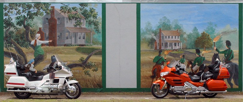
Exit 135 – Turbeville: Follow US 378 East: US 521
West: Town of Alcolu founded in 1885
as a mill town for Alderman Lumber Co.
Welded Sculpture: "The Swamp Fox Sets an Ambush" at FE DuBose Campus/CCTC Exit 122 – Manning: US 521 East:
(left side) Pond Bluff to St. Stephen's
Francis Marion - Reflections - 2 blocks West -
Mural
Historic Marker: http://www.hmdb.org/marker.asp?marker=51985 Santee National Wildlife Refuge / Fort Watson / Santee
Indian Mound. |
||
 ©2002
©2002
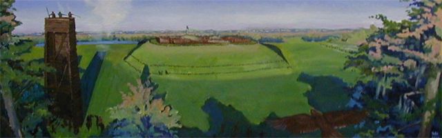
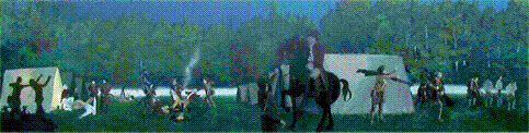
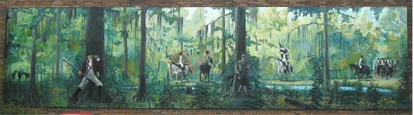
Siege of Fort Watson Mural This mural is made possible by the citizens of Clarendon County and SC Public Service Authority (Santee Cooper) to promote heritage tourism throughout the County. Artist is Will Anderson, Stateburg, SC, 2002. Come to Summerton for more Swamp Fox murals. Follow the Swamp Fox Murals Trail on Historic US 301: Summerton, Paxville, Manning, Turbeville |
||
 ©2002
©2002
Battle of Tearcoat Swamp Mural, Turbeville, adjacent to US 301 Follow the Swamp Fox Murals Trail: Turbeville, Manning, Paxville, Summerton Do a treasure hunt to find this mural "The American Revolution was won in the South in what is called the 'Civil War' phase." |
||
|
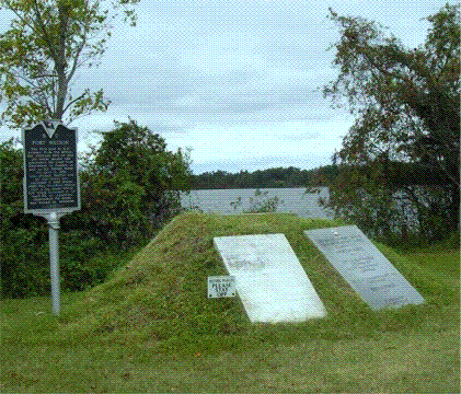
National Register of Historic Places - 1969 Historical evidence used for the "Archeology at Scott's Lake, 1973" and Wanton, 1939, support the ancient Indian Province of Cofitachiqui being located at the upper part of the Santee River. Records and maps from 1540's show that Cofitachiqui was at Scott's Lake, now Lake Marion, or near Pine Island Unit of Santee NW refuge. 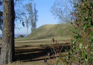 Santee Indian Mound was constructed as a ceremonial
and burial mound and there were many mounds
in this area. These mounds served as sub-structure
platforms for ceremonies almost 800 years ago.
Santee Indian Mound is included as part of the
Santee National Wildlife Refuge.
A current Santee Indian Chief
visited this site many times in 2000-2002.
The British built the fort on the mound because
of its strategic location. The British used it during
the Revolution to control movement on the Santee River
as well as the main road between Charleston and Camden.
In the third and final battle of Fort Watson, this
was the first post in South Carolina retaken from
the British. On April 15, 1871,
General Francis Marion and Lt. Col.
Henry "Lighthouse Harry" Lee encircled the fort and after 8
days of futile small arms fire, Major Hezekiah Maham
constructed a pine log tower of sufficient height to overlook
the defender's stockade. On April 23, 1781, the Americans
mounted an attack from the tower and from the ground
which lasted only a short time. Lt. McCoy surrendered
the fort, its garrison and supplies to General Marion, the
"Swamp Fox". (Located west of
I-95, Exit 102, US 301/15 to County Road 803,
9 miles SW of Summerton.)
Santee Indian Mound was constructed as a ceremonial
and burial mound and there were many mounds
in this area. These mounds served as sub-structure
platforms for ceremonies almost 800 years ago.
Santee Indian Mound is included as part of the
Santee National Wildlife Refuge.
A current Santee Indian Chief
visited this site many times in 2000-2002.
The British built the fort on the mound because
of its strategic location. The British used it during
the Revolution to control movement on the Santee River
as well as the main road between Charleston and Camden.
In the third and final battle of Fort Watson, this
was the first post in South Carolina retaken from
the British. On April 15, 1871,
General Francis Marion and Lt. Col.
Henry "Lighthouse Harry" Lee encircled the fort and after 8
days of futile small arms fire, Major Hezekiah Maham
constructed a pine log tower of sufficient height to overlook
the defender's stockade. On April 23, 1781, the Americans
mounted an attack from the tower and from the ground
which lasted only a short time. Lt. McCoy surrendered
the fort, its garrison and supplies to General Marion, the
"Swamp Fox". (Located west of
I-95, Exit 102, US 301/15 to County Road 803,
9 miles SW of Summerton.) |
||
|
||
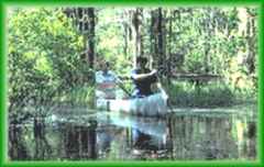
 Palmetto Trail
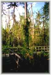
 "See wildlife at its best" The Lake Marion Passage of the Palmetto Trail is officially designated, August, 2000, in Clarendon County. By the end of 2006, the total mileage of the Trail across SC to more than 225 miles. This over 30 mile passage of the Palmetto Trail skirts along the high-water mark of the north side of Lake Marion. After crossing Lake Marion on Historic 301 bridge, the Lake Marion Passage winds along the high water mark of the lake, along Old River Road, between Fludd's Mill and the 'hauntingly beautiful cypress lagoon' Elliott's Mill Pond and behind SC Waterfowl Association. Commercial campsites along the trail include Jack's Creek Marina & Carolina King Resort, so hikers and bikers can stay on the trail for extended periods. Trail users will enjoy some of the most magnificent vistas in the Lowcountry with opportunity to spot abundant wildlife and colorful flora. Users have the possibility of encountering poisonous snakes and/or large alligators along the lake's edge. Only hikers and bikers may use this section of trail. The Lake Marion Passage is marked by yellow blazes in Clarendon County. Hikers and bikers should wear bright colors during big game hunting season, which is from the middle of August through January. |
||
|
|
||
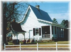
 The Old Manning Library
*C-20
The Old Manning Library
*C-20
National Register of Historic Places - 1979 The Old Manning Library, an imposing square
brick building on Brooks Street,
was built in 1908 by the same architects who built
the present Clarendon County Courthouse.
It is unique with a high domed sky-light. Entering
through the double doors, one steps into an octagon
shaped room, with four small rooms forming the
corners. |
||
|
Cuddo Unit Over 10 miles of roads and 3 miles of foot trails bring wildlife up close. This Visitor Drive is open for everyone to enjoy the Refuge, along the Lake Marion north shore. Wildlife viewing, walking, studying and photography are encouraged. Bank fishing is permitted April - September. Cuddo Unit is closed Saturdays during September - December. Primitive weapons hunting is allowed by permit during October. Follow Cuddo Unit, SNWR & John C. Land III Landing signs to the Cuddo Unit. |
||
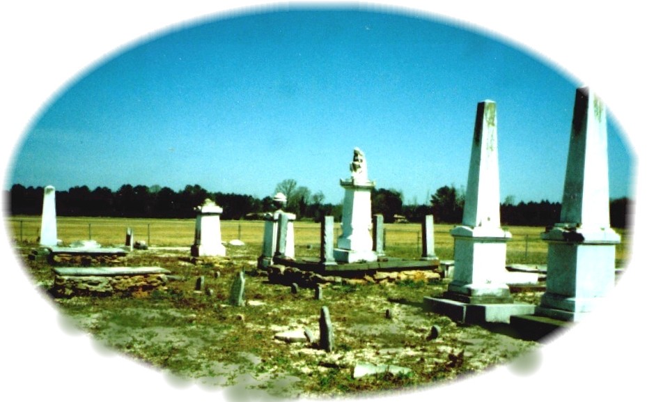
Cemetery and historical
marker are located on County Road 76, approximately 3 miles
SE of Rimini, from I-95, exit 108, west of Summerton.
One of the most historic & earliest graveyards
in St.Marks Parish, Richardson Cemetery, was founded
prior to the Revolutionary War.
In an attempt to force information concerning Francis Marion's
whereabouts from the widow, of General Richard Richardson,
Banastre Tarleton, a British general, compelled the widow, Dorothy,
to dig up the body of her husband laid to rest six weeks earlier.
Buried here also are Governors James Burchell Richardson, and
John Peter Richardson (founder of the Citadel). The most
Governors to ever be elected from one family were from the Manning/Richardson
family of Clarendon County. Ground penetrating radar also found
"Snowdrop", the horse, buried here. General Richard Richardson married
his first wife Mary Cantey (Mary, 1722-1769, daughter of William or Josiah)
on October 11, 1736 when this area was Prince Fredrick Parish. Below
is the inscription for him and Dorothy Sinkler Richardson, his second wife.
|
||
| Half-Way Swamp (modern name Elliott's Mill Pond) and Historic Marker: http://www.hmdb.org/marker.asp?marker=51466 | ||
|
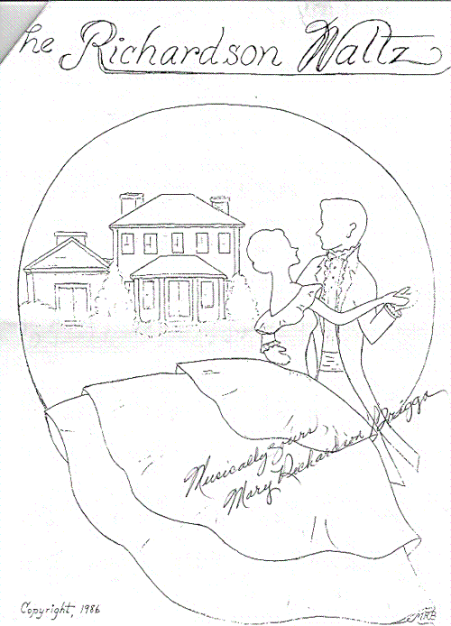
In the spring of 2000 "The Richardson Waltz" became the official South Carolina waltz. Mary Richardson Briggs of Clarendon County put the notes on paper for the first time in the 1980's. It had been handed down by ear from one generation to another for more than 200 years in the family of General Richard Richardson of the Snow Campaign and the Revolutionary War.
|
||
|
Established in 1941, the Santee National Wildlife Refuge has 15,095 acres: 1,425 acres of cropland, 2,350 acres of forest, 9,000 acres of open water, and 2,320 acres of shallow impoundments, ponds, marsh and swamp. Santee NWR was established to provide habitat and protection for migratory waterfowl and endangered species. In addition, the refuge provides opportunities for environmental education, interpretation and wildlife oriented recreation for visitors. The four management units of the refuge (the Bluff, Dingle Pond, Pine Island and Cuddo Units) stretch across 18 miles adjacent to the northern shore of lake Marion.  Approximately 100,000 ducks and 12,000 Canada
geese winter at the refuge, and more than 200
other species of birds live there or visit. Mammals
include bobcat, deer, raccoon, squirrel, mink, otter
and fox. More than 100 species of fish there
include chub, shiner, sucker, sunfish, bass, perch,
sturgeon, gar, shad, pike, catfish, swampfish, silverside,
crappie, needlefish, mullet and sole. January
is the peak month for Canada geese and mallards.
In February there is an increase of wood
ducks, purple martins and bluebirds. Alligators have been
sunning on some of the canal edges in March.
April and May are excellent months for
fishing. In August
the summer warblers begin to migrate south, but
September is the peak month for migratory
songbirds. Rubycrowned knights, white-throated
sparrows, finches, cormorants, hawks and bald eagles are
seen in October and November.December
is a good month to spot whistling swans and to fish
for largemouth bass, catfish and striped bass. Sport
fishing is permitted year round, but specific waters
are closed from November 1 through February 28. Located
west of I-95, Exit 102, US 301/15 to County
Road 803, 9 miles SW of Summerton.
Approximately 100,000 ducks and 12,000 Canada
geese winter at the refuge, and more than 200
other species of birds live there or visit. Mammals
include bobcat, deer, raccoon, squirrel, mink, otter
and fox. More than 100 species of fish there
include chub, shiner, sucker, sunfish, bass, perch,
sturgeon, gar, shad, pike, catfish, swampfish, silverside,
crappie, needlefish, mullet and sole. January
is the peak month for Canada geese and mallards.
In February there is an increase of wood
ducks, purple martins and bluebirds. Alligators have been
sunning on some of the canal edges in March.
April and May are excellent months for
fishing. In August
the summer warblers begin to migrate south, but
September is the peak month for migratory
songbirds. Rubycrowned knights, white-throated
sparrows, finches, cormorants, hawks and bald eagles are
seen in October and November.December
is a good month to spot whistling swans and to fish
for largemouth bass, catfish and striped bass. Sport
fishing is permitted year round, but specific waters
are closed from November 1 through February 28. Located
west of I-95, Exit 102, US 301/15 to County
Road 803, 9 miles SW of Summerton. |
||
 Woods Bay State Park has 1, 541 acres, most
of which are open savannah near the pointed end
of the egg-shaped bay, and dense cypress swamp
elsewhere. At the edge of the bay are sandy flats
with loblolly pines and turkey oaks, and on the north
side adjacent to the bay is the Mill Point Pond.
The park was named after Andre Woods, who once owned a
gristmill at the pond. Wildlife is prominent, including
numerous species of wading, perching birds. The
land was purchased in 1973, and the facilities include
nature study, canoeing, picnicking and fishing. Located
east of I-95, Exit 135 to US 301
north of Turbeville.
Woods Bay State Park has 1, 541 acres, most
of which are open savannah near the pointed end
of the egg-shaped bay, and dense cypress swamp
elsewhere. At the edge of the bay are sandy flats
with loblolly pines and turkey oaks, and on the north
side adjacent to the bay is the Mill Point Pond.
The park was named after Andre Woods, who once owned a
gristmill at the pond. Wildlife is prominent, including
numerous species of wading, perching birds. The
land was purchased in 1973, and the facilities include
nature study, canoeing, picnicking and fishing. Located
east of I-95, Exit 135 to US 301
north of Turbeville. |
||
|
||
|
Civil rights leaders Harry Briggs and Joseph A. DeLaine were born in Clarendon County. Their home church, Liberty Hill Church, at St Paul, was instrumental in the landmark de-segregation case that was combined into the Brown vs the Board of Education Supreme Court case of 1951-1954. |
||
|
Bennett's Bay & Dingle Pond (Carolina Bay part of Santee National Wildlife Refuge) are in Clarendon County. There are hundreds of shallow, elliptical depressions known as bays in the state's coastal plains. The bays always are egg-shaped, aligned from northwest to southeast and have a sand ridge that's usually visible on the southeast side. Some of the depressions are dry; others are swamp, and a few others are beautiful lakes. They range in diameter from a few hundred feet to five miles. 'These things are priceless. They hold moisture in times of drought and slowly release it to the surrounding area. They are an oasis for wildlife." Attempts to explain this natural phenomenon - unique to the Carolinas - include the meteorite theory (the most accepted theory), the ancient springs theory and the ancient ocean lagoons theory. |
||
| Battle of Wyboo Swamp Site & Historic Marker: http://www.hmdb.org/marker.asp?marker=51986 , just north of Santee Dam, Patriots Road. | ||
|
"Lake Marion is rated one of the top 5 freshwater fishing lakes in the world." Approximately 15 miles S. of Manning on Hwy. 260, Santee Dam is the most sizable earthen dam in South Carolina - 8 miles long. Lake Marion is named in honor of General Francis Marion, the Revolutionary War hero, "The Swamp Fox".  in particular the Striped Rock Bass, normally
an ocean fish. When the dam gates
were closed, the stripers were landlocked in the reservoir
and began to produce in the fresh waters. Some
weigh up to 50 lbs. Countless vacation cottages and
homes have been built along the 475 miles of shoreline.
Santee
Cooper Country is important today for its value to sportsmen
and for the electric power it was built to produce. Thus
- for all practical purposes - the Santee Cooper
Rivers are now one and the same except during the discharge
of major flood waters. (Photos
Courtesy The Manning Times ©2000 & Santee
Coooper)
in particular the Striped Rock Bass, normally
an ocean fish. When the dam gates
were closed, the stripers were landlocked in the reservoir
and began to produce in the fresh waters. Some
weigh up to 50 lbs. Countless vacation cottages and
homes have been built along the 475 miles of shoreline.
Santee
Cooper Country is important today for its value to sportsmen
and for the electric power it was built to produce. Thus
- for all practical purposes - the Santee Cooper
Rivers are now one and the same except during the discharge
of major flood waters. (Photos
Courtesy The Manning Times ©2000 & Santee
Coooper) |
||
|
National Register of Historic Places - 1983 SC Road 63/Racoon Road, South of Manning Alderman's 20 Stores in One (1919) National Register of Historic Places - 1994 34 & 36 Brooks Street, Manning |
||
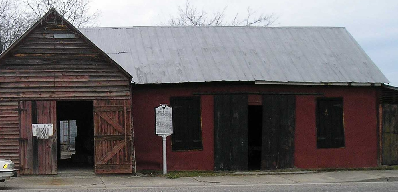
9 Cantey Street, Summerton (I-95, exits 108 or 115) This complex is a significant example of a type of commercial enterprise once common in small towns of the rural South. This complex features a a blacksmith shop (ca. 1903), grist mill (ca. 1905), and bottling plant (ca. 1921) and was operated by the Senn family members (John G., Frank W. Josey, and Walter B. Senn, Jr.) for nearly 100 years. |
||
|
Alcolu was est. between 1885 & 1890 as a mill town for the Alderman lumber co. As a company town, everyone worked at the mill, took babbit to the company store & could buy groceries, see the doctor or watch a show in the 200 seat theater upstairs. The store looks like early 1900's & has antiques. |
||
Note: *C #s are Historical Tour Guide Map Signs Historical Tour Guide * Visit over 50 historical sites with the Tour Guide Map, available at the Manning, South Carolina 803-435-0328 Return to Clarendon Murals homepage |
||
|
For more info or questions, contact:
G Summers: 803-478-2645
or email gcsummers@ftc-i.net
|
 ©2001
©2001

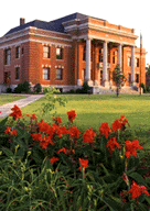 Clarendon County Courthouse,
Town Square, Manning *C-23
Clarendon County Courthouse,
Town Square, Manning *C-23